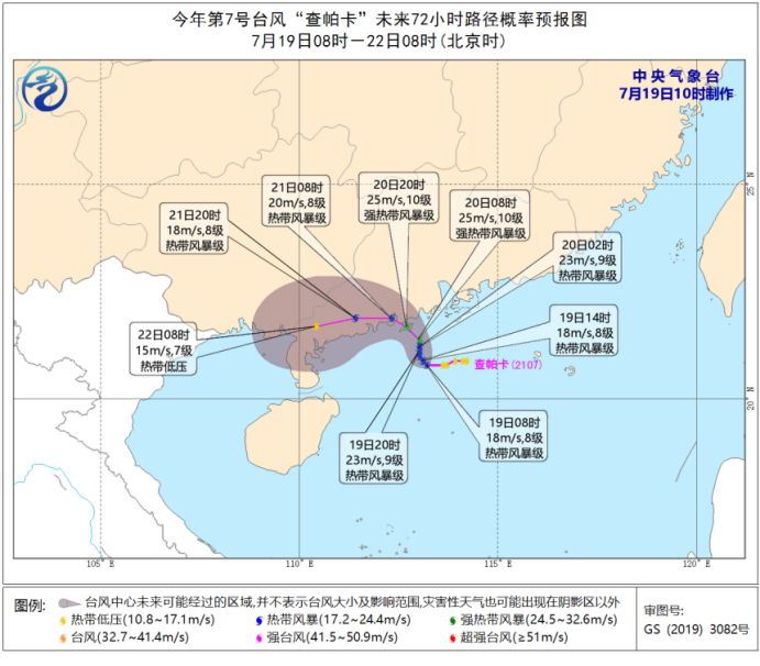
This year’s No.7 typhoon "Chapaka" generated the China Meteorological Bureau: it is expected that its intensity will gradually increase.
Cctv newsAccording to central weather bureau news, following the generation of Typhoon No.6 "Fireworks" this year, the tropical depression in the South China Sea was strengthened to Typhoon No.7 this year at 8: 00 am on July 19 (tropical storm level; Chinese name: Chapaka; English name: Cempaka;; Name source: Malaysia; Name meaning: a plant famous for its fragrant flowers.
At 8 o’clock, the Chapaka center is located on the sea about 175 kilometers southeast of Yangjiang City, Guangdong Province, and the maximum wind force near the center is 8 (18 m/s). It is expected that its intensity will gradually increase, and it will land on the southern coast of Guangdong from the night of 20th to the early morning of 21st (tropical storm level or strong tropical storm level, 8-10, 20-25m/s); It is also possible to wander around the sea surface in the central and western Guangdong, and then move to the northeast. Affected by this, there will be strong wind and rain in central and southern Guangdong and coastal areas. Please pay close attention to the nearby weather information in time and take relevant preventive measures.
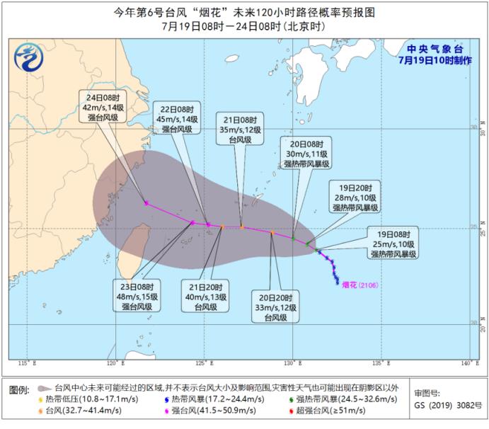
This year’s No.6 typhoon "Fireworks" is stronger than yesterday, and continues to move to the north-north direction, and its intensity is gradually strengthened, and the strongest can reach typhoon level or strong typhoon level (40-48 m/s, 13-15); On the 21st, it moved into the East China Sea, and then gradually approached the coast of Fujian and Zhejiang. Because of the uncertainty of its future moving path and intensity, the Central Meteorological Observatory will pay close attention to its trend and provide the public with forecast and early warning information in time.